№ 079Singapur
Plano del metro de Singapur
Mass Rapid Transit es el sistema de metro de Singapur, Singapur. Se inauguró en 1987 y hoy tiene 146 estaciones en 6 líneas; la red se extiende unos 39 km. Ocupa el puesto 32 del mundo por número de estaciones.
Pasaporte del metroSe guarda solo en este navegador.
Desplázate y el esquema se convierte en la ciudad. Índice de distorsión 59,3: cuanto más alto, más se aleja el esquema de la geografía. El esquema se genera automáticamente con datos de OpenStreetMap; no es el plano oficial.
- Inauguración
- 1987
- Líneas
- 6
- Estaciones
- 146
- Longitud
- 246,6 km
- Pasajeros al año
- 1240 mill.
Líneas y estaciones: OpenStreetMap; el resto: Wikidata.
Plano oficial
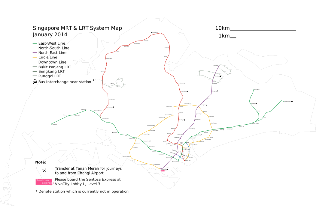

La red sobre el mapa
Líneas en sus colores oficiales sobre la geografía real. Los transbordos son los anillos más grandes.
Líneas 6
| Línea | Terminales | Estaciones |
|---|---|---|
| CCLMRT Circle Line (Prince Edward Road → Dhoby Ghaut) | Prince Edward Road → Dhoby Ghaut | 33 |
| DTLMRT Downtown Line (Bukit Panjang → Expo) | Bukit Panjang → Expo | 35 |
| EWLMRT East-West Line (Tuas Link → Pasir Ris) | Tuas Link → Pasir Ris | 35 |
| NELMRT North East Line (Harbourfront → Punggol Coast) | HarbourFront → Punggol Coast | 17 |
| NSLMRT North-South Line (Marina South Pier → Jurong East) | Marina South Pier → Jurong East | 27 |
| TELMRT Thomson–East Coast Line (Woodlands North → Bayshore) | Woodlands North → Bayshore | 27 |
Cómo usarlo
- Billetes y tarifas
- Tarifa por distancia. Acerca una tarjeta bancaria sin contacto o el móvil (SimplyGo) o compra una tarjeta EZ-Link; el Singapore Tourist Pass da 1 a 3 días ilimitados. MRT, LRT y autobuses forman un solo sistema tarifario con descuentos por transbordo.
- Horario
- Aproximadamente de 5:30 a 0:30.
- Conviene saber
- Prohibido comer y beber en estaciones y trenes; los durianes están totalmente prohibidos.
- El aeropuerto de Changi está en la línea East–West por un ramal corto desde Tanah Merah.
- Estaciones frescas e impecables, con puertas de andén en todas las líneas.
Comprobado en septiembre de 2026. Las tarifas y los horarios cambian: confírmalos en el sitio del operador antes de viajar. · Sitio oficial ↗
- n.º 32 de 213 Más estaciones
- n.º 29 de 213 Longitud de rutas (OSM, variantes principales)
- n.º 79 de 214 Más antiguos
- n.º 31 de 147 Más estaciones de transbordo
- 43 m bajo tierra, la estación más profunda, Bencoolen
Comparar con: Nueva York · Shanghái · Seúl · Changsha
Respuestas rápidas
- ¿Cuántas estaciones tiene el metro de Singapur?
- 146 estaciones en 6 líneas según OpenStreetMap; la cifra oficial es 146.
- ¿Cuándo se inauguró el metro de Singapur?
- La primera línea se inauguró en 1987.
- ¿Cuál es la línea más larga del metro de Singapur?
- EWL MRT East-West Line (Tuas Link → Pasir Ris): unos 50 km y 35 estaciones.
- ¿Cuál es la estación más profunda?
- Bencoolen: 43 m bajo la superficie (fuente: Land Transport Authority).
Datos y autoría
- Mass Rapid Transit: Benoit Mortgat ( Pabix ) · CC BY-SA 3.0 · Wikimedia Commons
- © Colaboradores de OpenStreetMap, ODbL · openstreetmap.org/copyright
- Cifras: Wikipedia, lista de sistemas de metro
- Datos a 13 de septiembre de 2026 · Avisar de un plano desactualizado